Die Stiftung Heidelberg Laureate Forum Foundation lädt Sie vom 5. Juli bis 2. August 2015 im Karlstorbahnhof Heidelberg ein, die Ausstellung „Mathematik des Planeten Erde“ zu besuchen. Die Ausstellung ist zum ersten Mal in Heidelberg und verspricht für Jung und Alt ein abwechslungsreiches und spannendes Erlebnis.
Karten der Erde
Programm
Program (zip, Windows installer). See below documentation and other platforms
Licenses
Source code
Autoren
This program has been developed by Daniel Ramos, MMACA (Museu de Matemàtiques de Catalunya).
"An Album of Map Projections", 1989, Snyder, John P.; Voxland, Philip M. Credit: U.S. Geological Survey
Department of the Interior/USGS
Mitwirkende
Programming and DesignDaniel Ramos
Zugehörige Events
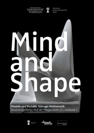
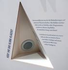
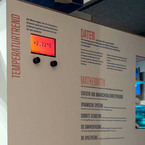
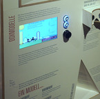
MIND AND SHAPE ist eine dauerhafte Ausstellung an der Universität Tübingen. Sie gibt einen Einblick in die Gedankenwelt der Mathematik. Die Ausstellung zeigt neben Modellen auch Porträts der prägenden Köpfe des Fachbereichs. Am Touchscreen können Sie mithilfe von IMAGINARY-Programmen Geometrie interaktiv erleben und Schnappschüsse moderner Mathematik aus Oberwolfach lesen und an Ihre Emailadresse senden.
Mathematikstudentinnen und -studenten der Universität Tübingen führen Schulklassen und andere interessierte Gruppen durch die Ausstellung. Sie haben in einem von JProf. Carla Cederbaum und Sophia Jahns Workshop geleiteten Workshop trainiert, die Exponate einer breiten Öffentlichkeit zu erklären und die Schönheit der Mathematik zu vermitteln.
Bei Interesse an einer Führung wenden Sie sich bitte an frank.loose@uni-tuebingen.de
Die erste MPE2013-Ausstellung, auf der die prämierten Exponate des MPE2013-Wettbewerbs gezeigt werden, findet in Zusammenarbeit mit IMAGINARY vom 5. bis 8. März 2013 in den Räumlichkeiten der UNESCO in Paris statt.
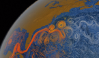
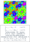
Dieses Programm beschäftigt sich mit Kartographie und der Geometrie der Sphäre. Die geometrischen Eigenschaften einer Sphäre und einer Ebene sind grundsätzlich verschieden, sodass keine Karte die Erde ohne Verzerrung abbilden kann. Dieses Modul behandelt einige dieser Eigenschaften und vergleicht verschiedene Karten anhand der verwendeten Projektionen. Man kann ein Gefühl für den Begriff „Verzerrung“ bekommen und die Frage beantworten, warum es keine „perfekte Karte“ geben kann.
Studying the problem of representing the spherical surface of the Earth onto a flat map is the subject of cartography, and has been an important mathematical problem along History (navigation, position, frontiers, land ownership…). An essential theorem in Geometry (Gauss’ Egregium theorem) ensures that there is no perfect map, that is, there is no way of representing the Earth keeping distances at scale. However, this is exactly what makes cartography a discipline: developing several different maps that try to solve well enough the problem of representing the Earth.
We present six different map projections that are to be compared with a physical globe. Although all maps are created at nominal scale 1:1 of the globe, the distortion is apparent. We propose several activities with the maps and some tools that explore the properties of each map.
On a second part, we use the program „The sphere of the Earth“, that displays the Tissot indicatrix for each map. This indicatrix is a mathematical graphical tool that helps to understand the inherent distortion of a map. When moving the mouse over a map, an ellipse is drawn around the pointer; this ellipse represents actually a real circle, but the distortion of the map makes it appear in this shape. The inspection of this ellipses at different points tells us a lot of information about the projection properties.
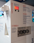
Files to download include the six maps at poster size, the script programs that generate them, the program displaying Tissot indicatrices, a technical manual and a set of proposed activities.
This exhibit was awarded the first prize in the „Mathematics of Planet Earth 2013“ competition.