Der Tunnel von Samos
Programm
Licenses
Source code
Webseite
Mitwirkende
Beschreibung der Heron-Methode, die wahrscheinlich für den Bau des Tunnels von Samos benutzt wurde
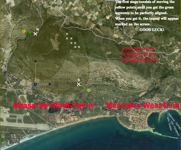
Der Hafen von Samos war von großer strategischer Bedeutung, nur leider hatte er keine Quelle, die ihn mit Trinkwasser hätte versorgen können. Der Auftrag für Euplanius, einen Architekten im 6. Jahrhundert vor Christus, war also der Bau eines Tunnels durch den angrenzenden Berg, der als Aquädukt zwischen dem Nordeingang N und dem Südeingang S benutzt werden könnte. Um Energie zu sparen, sollte der Tunnel möglichst gerade verlaufen.
Um außerdem so schnell wie möglich fertig zu werden, entschied sich Euplanius, von beiden Seiten anzufangen zu graben. Dabei ergaben sich zwei große Schwierigkeiten:
The Samos harbour had a great strategic importance, but it didn´t have a spring which supply it with drinkable water.
The task that Eupalinus received from the tyrannus of Samos was to dig a tunnel through the mountain to be used as a aqueduct between the northern entrance N and southern one S.
In order to save energy, the tunnel had to be as straigh as possible. In order to spend less time, he decided to start digging from both sides. To take measurement on the horizontal plan, the references had to be at the same level. In the map.
The activity we propose consists of two parts:
A) Find the exact location of the excavation. It is an exercise of great precision, since the minor error at
the beginning would make the tunnels not to find each other or not to do it a straight way.
B) Locate the point where the North and South drillings should meet if they work at the same pace
on both sides.
We indicate some suggestions on the map, none of them on how to get to Samos …
Two versions of the activity are proposed, Samos tunnel and step by step
Authors: Bernat Ancochea, José María gallego & Javier Martín